Time to Eat the Dogs
A Podcast About Science, History, and ExplorationReading the Map
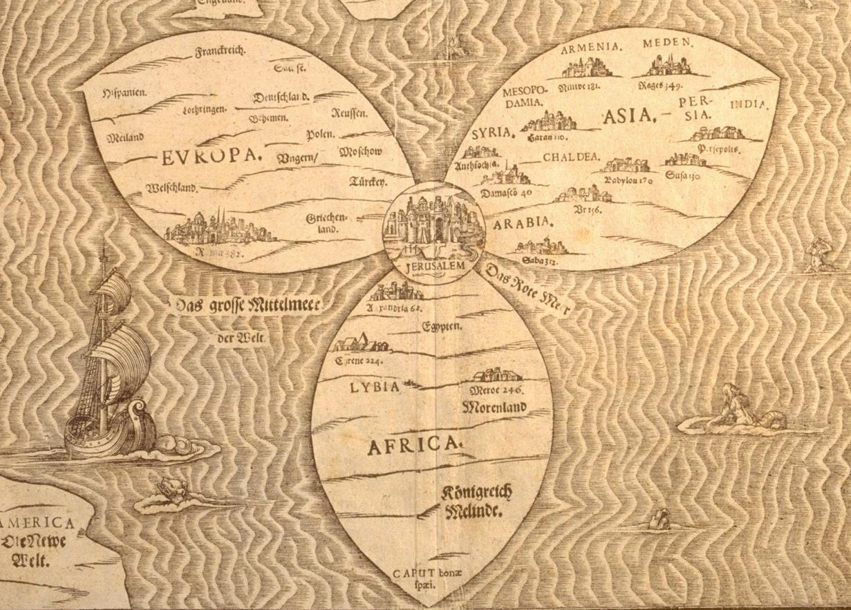 Jerusalem World Map, Heinrich Bunting, 1581 (courtesy of the Osher Map Library)
For the last two weeks, we’ve been on a long road trip: from Connecticut to Ohio, Illinois, upstate Michigan, and back to CT. As journeys go, it was not perhaps as impressive as, say, Scott’s trek to the South Pole. He ate pemmican, we ate cheetos. He drove sledges, we drove an Odyssey. His party suffered from scurvy, ours sunburn. Yet we achieved our own kind of glory: 2600 miles, 50 hours in a minivan, with two adults, two children, and one toddler, aged 1.5. No one perished from strangulation or defenestration, none were committed to asylums, none have talked to the press. Victory is ours.
Yesterday, at the end of a particularly long leg, we found ourselves on Rte 80 in northern Ohio, looking for a meal that would please all and could be had fast. In other words, pizza. But where to look in the rolling cornfields of Ohio? We got off 80 and asked the toll booth attendant. She couldn’t think of any place that made pizza. What planet had we landed on? Michele and I consulted our road atlas, a misshapen, parchment-colored thing, to see if we could glean a site out of the black and red lines and place names.
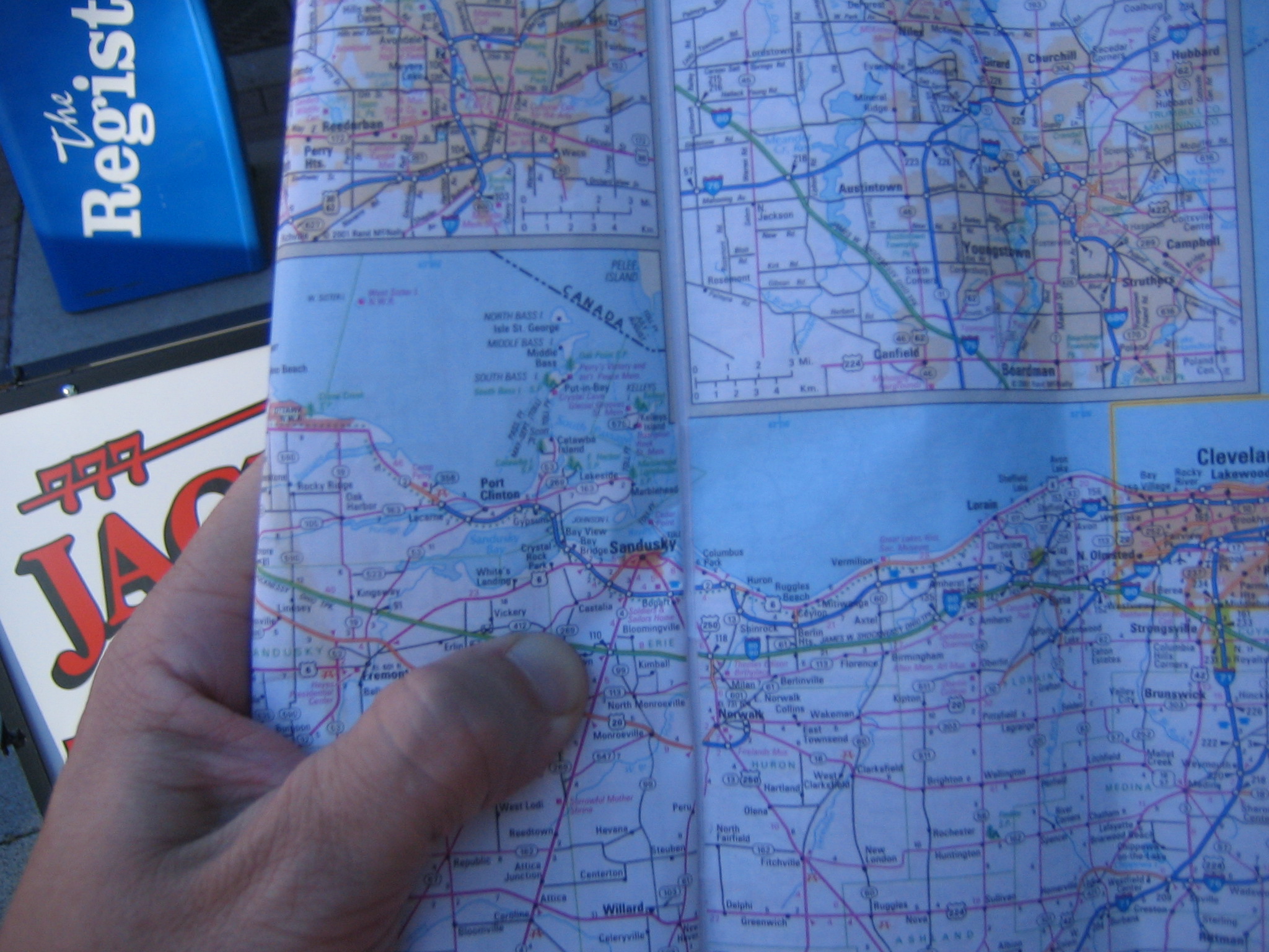
After some debate, we decided upon the town of Sandusky, about eight miles off of the highway from the exit. While it might have been possible to find pizza closer, it seemed unlikely to us that these small, silo-dotted towns would produce a pie to satisfy our elitist, bourgie palate. Without knowing anything else about the town of Sandusky, I liked the name, it sounded old, Polish perhaps? If so, I would imagine that it was settled in the early- or mid-19th century. Old Midwestern towns, I knew, were often built small and compact to accommodate walking traffic. These towns, with main street and thick brick commercial buildings, are now favorites of urban renovation, of ice cream shops, restaurants, and gourmet pizza. Sandusky, is this you? Moreover, the town was right on Lake Erie, at a point very close to the Canadian coast due north of the city. I saw them in my mind: hungry Canadian tourists climbing off the boat to celebrate summer at their favorite waterfront pizzeria.
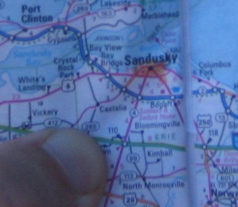
This was all a wild, sherlock-holmesian, stab in the dark. There was no evidence to back up this speculative conjuring from a 1996 Ohio road map. Yet in the end, we were right to head to Sandusky. It was indeed a place we imagined: an old city with downtown, sidewalks, old buildings, and waterfront. Local residents told me that it was struggling to become the renovated, gentrified place that sometimes take root in down-on-their-luck industrial towns. More importantly, we found our parlor, the “Mona Pizza” on the main street perpendicular to the waterfront.
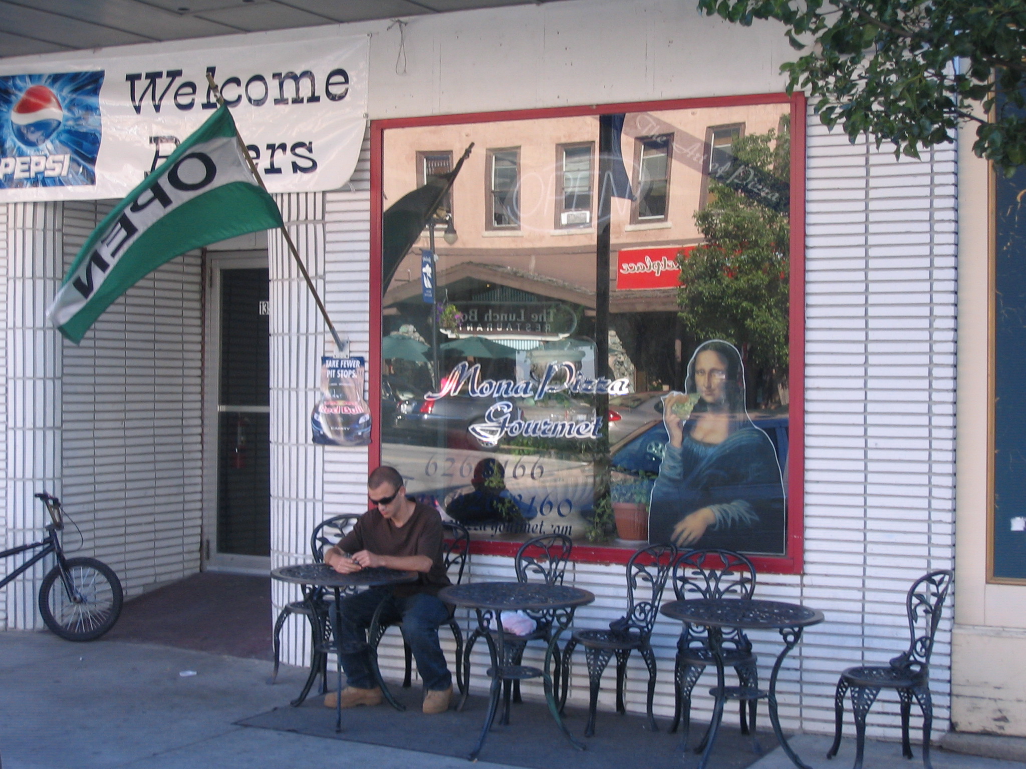
Mona Pizza, with its “Welcome Bikers!” sign, was was not quite the bourgie place I had imagined. But it counted where it mattered, offering up a tasty, New-York-style, thin-crust pie in 20 minutes.

All of this got me thinking about maps. Historians of many stripes are savvy in how they read visual documents, from pictures, paintings, and illustrations to maps. However precisely surveyed, however carefully rendered, maps and landscape are subjective documents, painted with the hues of culture as well as pigment. A long look at one of the landscapes of Frederic Church, for example, tells a great deal about Church’s vision of the country and of the United States as an emerging empire.
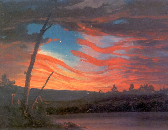
Frederic Church, “Our Banner in the Sky,” 1863
Yet it seems from what I’ve read (and from the visual analysis that I’ve done myself) that much of this analysis is focused on the object. That is, the question most commonly asked is “How do the historical artifacts carry culture?” Reading the road map of Ohio, I realized that many of our decisions had to do with our own cultural baggage as viewers, of our knowledge of Midwestern towns, our study of American history, our snooty notions of good pizza. Put more broadly, the Sandusky experience made me wonder how the individual subject encounters the map. How does the subject shape the map’s reading? This is a difficult question to answer. We all bring different things to our interpretation of maps, documents, indeed, virtually everything we come into contact with.
But it brought me back to issues of exploration.
For many academics, especially in the humanities, the world is a place divided into those-who-do (them) and those-who-interpret-what-others-do (us). Generally, relations tend to fall apart on the subject of “experience.” In the eyes of explorers, for example, historians can never fully understand events in the field because they weren’t there themselves. Historians, on the other hand, point to the importance of this distance from the field – of the biases that naturally result from close involvement in a project – in portraying events even-handedly. As one of the chronicler-class rather than the doer class, my sympathies have always been with my academic posse in this debate.
But reading the map of Sandusky, I realized the importance of the viewers’ perspective in reading the map. And in terms of my work, I realized the great gulf that separates the experience of explorers (both western and indigenous) from those of us who seek to figure them out. How, for example, did Robert Peary’s experience of the ice cap, or the Greenland ice sheet, shape the way he viewed such places inscribed on paper? How did James Cook’s knowledge of Atlantic currents shape the way he read his sketchy maps of the Pacific? Looking at these same maps, what did Cook’s Tahitian guide Omai see rendered there?

Digital Archive: David Rumsey Map Collection

Gardner’s Comparative Heights of Mountains and Rivers, 1823
When I was a young, baby-faced graduate student at the University of Wisconsin-Madison, I had the good fortune of attending a series of lectures by Simon Schama on his new book Landscape and Memory. Schama presented a cultural history of landscape in Europe (mountains, rivers, forests). He was compelling as a lecturer, impressive in his arguments. But man, did he have good slides. I had already begun to settle into the history of exploration as my thesis area. But I had always imagined that I would approaching this material from the world of text: logs, journals, scientific monographs, etc. As Schama delivered his lectures (they took place over three days), his slides were more than eye-candy, they were arguments. This may sound silly, but I never thought about the visual artifacts of exploration as evidence until that moment. In any event, I am always on the lookout for good expeditionary photos, engravings, etc. Over the next few posts, I hope to share some sites with good pickings for those of you who are visually inclined.
David Rumsey started digitalizing his map collection twenty years ago. He now has over 17,000 of them scanned, online, free of access to all. There are some amazing maps here, authored by Lewis and Clark, James Cook, and Alexander von Humboldt among others. You will need to download one of the specialized browsers on his site, but once this is set up you can view thousands of exploration maps in all of their hi-def grandeur and download them too. One of the best features is the document notes available with each map. Sometimes these offer secondary source notes useful for explaining context, etc.
Have fun: http://www.davidrumsey.com/
Book Review: The Lost Land of Lemuria
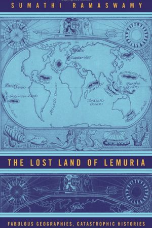
Sumathi Ramaswamy. The Lost Land of Lemuria. Fabulous Geographies, Catastrophic Histories. xv + 334 pp. illus., figs., index. California: University of California Press, 2004. $21.95 (paper).
The world has many mythic places: the Garden of Eden Atlantis, El Dorado. Opinion about these places usually breaks down into two camps. Believers defend them as real, lost to the modern world through acts of natural or divinely-induced catastrophe. Skeptics see them as fantasies, the labors of a blinkered imagination. Missing from this debate over real or fantasy is the cultural function of lost worlds in human society. For Ramaswamy, this is the starting point for her project. “What is a lost place? What symbolic capital does a lost place command that an available place does not?” (3) Her case study is Lemuria, a lost continent that some believed stretched over large parts of the Indian Ocean. The story of Lemuria begins in 1864, when British zoologist Philip Sclater published an essay, “The Mammals of Madagascar” in the Quarterly Journal of Science.
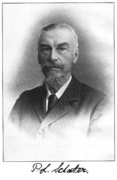
Sclater observed several similarities between the species of Madagascar and India, particularly in the distribution of lemurs. To Sclater, this suggested that Madagascar and India were once part of the same continent, a place he playfully called “Lemuria.” Scientists such as Thomas Huxley, Alfred Russell Wallace, and Ernst Haeckel seriously debated the existence of Lemuria, an idea made plausible by catastrophist theories of geology and biogeographical evidence in the field. Yet support for Lemuria waned as Alfred Wegener’s continental drift theory gained support in the twentieth century. Wegener provided an alternate, compelling explanation for the biogeographical similarities between Madagascar and India: these regions had once been connected and then drifted apart millions of years ago. But while support for Lemuria petered out among scientists, it lived on in two communities which Ramaswamy dubs “eccentric and off-modern”: Western occultists and Tamil devotees in southern India. For occult organizations such as the Theosophical Society and its twentieth century New Age offshoots, Lemuria offered a way of anchoring the idea of lost continents, central to their creation stories of the world, to the work of respected scientists. For Tamil devotees, the lost continent of Lemuria lent credibility to the idea of an ancestral Tamil homeland, Kumarinatu, that they believed was destroyed by the sea. In each of these cases, the story of Lemuria’s destruction was a creative act, one that required “labors of loss.”

Lemurs
This is an impressive work. While Ramaswamy is not the first scholar to attempt a cultural analysis of mythic places, the scope and depth of her analysis raise the bar for scholars who follow. Not only does she demonstrate how Lemuria (and by extension other mythic worlds) gain their power by appearing in the modern world as “lost,” she also shows how the role of Lemuria evolves in three very different communities. That Ramaswamy is at ease discussing biogeography, New Age philosophy, and the texts of Tamil devotion shows her great flexibility and synthetic powers as a scholar. Unfortunately, few readers will be able to make it through the thicket of Ramaswamy’s prose to complete The Lost Land of Lemuria. Written in the language of post-colonial critique, it is at times too comfortable with showing that processes are complicated and contradictory. To offer one example:
Labors of loss around Lemuria occupy the vortex of the dialectic constituted by the opposing pulls of the will to disenchant and the rush to re-enchant. Modernity’s discontents are thus both disabling and enabling for the preoccupations of loss around this vanished land. (10)
Lemuria is also a place that burgeons with hyphens. It is a land of place-worlds and life-worlds, inhabited by the non-modern, off-modern, and the counter-disenchanted. While “loss” is a central concept for this book, the term rains down on the reader relentlessly, in chapter titles (all except one), subheadings, and on almost every page. What is most upsetting here is not that The Lost Land of Lemuria is difficult to read. It is that the language will keep it from audiences who should be reading it. Ramaswamy tells us how important it is to give voice to groups who are marginalized by the Western paradigms of science and history, but she has written a book that – significant as it is- will only be discussed within the ramparts of the academy.
Thanks to University of Chicago Press for permission to re-print this review. It first appealed in the journal Isis December 2006, 97 (4): 775-776.
Lost Tribe, Now Found
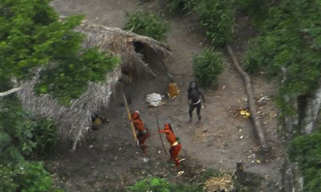
It turns out that the ‘lost tribe’ widely reported to have been found in the Brazilian rain forest a few months ago had only been temporarily misplaced. In truth, the Brazilian Indian Protection Agency (Funai), had known about this nomadic group for years.
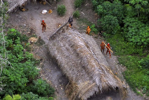
The Guardian states:
Survival International, the organisation that released the pictures along with Funai, conceded yesterday that Funai had known about this nomadic tribe for around two decades. It defended the disturbance of the tribe saying that, since the images had been released, it had forced neighbouring Peru to re-examine its logging policy in the border area where the tribe lives, as a result of the international media attention. Activist and former Funai president Sydney Possuelo agreed that – amid threats to their environment and doubt over the existence of such tribes – it was necessary to publish them.
Two things strike me. First, we expect hard-ball tactics and outrageous propaganda from anti-environmental groups, but not from our idealistic conservationists. Were it only a matter of making something up, ok, bad enough. But strafing a village in order to get the photos? Poor form indeed. The former Funai president Sydney Possuelo defends the lie by saying it has caused Peru to reassess its logging practices. Yes, perhaps. But in the process it has destroyed the credibility of Funai and weakened the claims of other conservationists by association.
Second, what is behind our fascination with “lost” objects anyway? Sumathi Ramaswamy writes about this in The Lost Land of Lemuria: Fabulous Geographies, Catastrophic Histories (California: University of California Press, 2004). Loss, in her analysis, is a constructed thing, something we “make missing” in the past to satisfy social or political concerns in the present. (I will post a full book review on Thursday). The theme of the lost civilization or tribe catches fire in the nineteenth century and keeps burning into the 20th. For examples, see Journey to the Center of the Earth by Jules Verne (1864) or the The Wonderful Wizard of Oz by L. Frank Baum (1900)). The eagerness to capture lost peoples and places comes just as white Americans begin to seriously fret about the closing of the American frontier, race suicide, and manly decline (see Manliness and Civilization: A Cultural History of Gender and Race in the United States, 1880-1917 by Gail Bederman for a good synopsis of this). In any event, the Funai hoax proves that cult of the lost tribe is still alive and well in the 21st century. What gives?
A Question For You
I’ve been talking with Will Thomas at Ether Wave Propaganda about starting up a wiki, an open source database for people working on subjects in exploration. There is, of course, wikipedia. But a quick perusal of their main page on exploration lead me to think that this will only deal with nuts and bolts issues in the field (i.e. lists of explorers, timelines, regions, etc). What about a database that would include (perhaps even focus on) issues that were too wonky or obscure to be of use for a general interest resource like Wikipedia? As Will states in his post:
Wikipedia’s rules demand that pages be summaries of topics–not storehouses of all available information; and it is forbidden to post original scholarship there. Wonks need to turn elsewhere.
This, perhaps, puts some of us on edge. We don’t mind talking shop about general subjects, but sometimes it feels a bit dangerous to start revealing archival discoveries in advance of a published article. Perhaps this is a real concern, though I’ve never known someone to get scooped in this manner. When I’ve heard about it happening it was in the context of faculty members using material from research assistants or advisees without properly citing it.

The Exploration Wiki deep within Cheyenne Mountain
Even if it were true, it seems that there are all kinds of “common source” subjects that are both useful and non-proprietary. For example, I wrote a post last week on the historical connotations of exploration. This seems a bit too precise for the wikipedia discussion on exploration At the same time, my 500 word post is only the tip of the iceberg on ideas about exploration – I would love to know what others think about this: anthropologists, geographers, lit critics, and general public. Even if the wiki entry was nothing more than a compendium of various historical references to the subject, it would be useful I think. It also seems to me that a lot of us work on fairly obscure figures or ideas in the history of science and exploration – why not have a place for all of this esoterica to live?
Missing: Obscure Explorer, Needs Home.
At the same time, I don’t want to be pouring my energies into something that should be done through wikipedia, a blog carnival, or some other medium. Or, whether such a project should come under the heading of a larger wiki (e.g. the history of science) In any event, I would love to hear your thoughts, dear reader. Is this worth pursuing?


