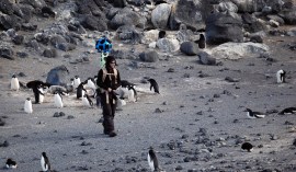
Cole Kelleher walks through the Adélie penguin colony at Cape Royds
Cole Kelleher talks about his work for the Polar Geospatial Center at the University of Minnesota, an agency that uses satellite data to support polar scientists in the field. In addition to making maps, Kelleher works with polar scientists, and coolest of all, has teamed up with Google to provide street views of McMurdo Station in Antarctica (see links below).

Cole Kelleher
Links:
Antarctica Street Views on Google:


This was fascinating, to hear someone who is on the front lines of exploring our most inaccessible regions of the planet and even changing and augmenting the way exploration is done in the modern world. Really great interview!