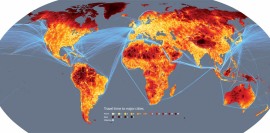
Travel times to major cities. Shipping lanes in blue. Image Credit: NewScientist
This week, NewScientist announced the remotest place on earth: 34.7°N 85.7°E, a cold, rocky spot 17,500 ft up the Tibetan Plateau. From 34.7°N 85.7°E it takes three weeks by foot to reach Lhasa or Korla.
Not that anyone has tried. No council of explorers advised NewScientist on its choice of locations. It was determined by using geographical information systems (GIS) which combined number of factors, including:
information on terrain and access to road, rail and river networks. It also consider[ed] how factors like altitude, steepness of terrain and hold-ups like border crossings slow travel.

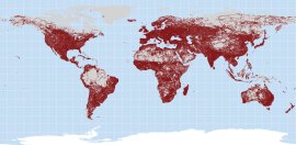
The world's roads. Image credit: NewScientist
Nineteenth century maps still occasionally showed regions of Terra Incognita. But twenty-first century maps have no blank spaces left. The NewScientist maps offer, in their measure of “most remote” a modern equivalent.

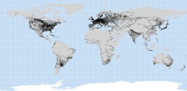
The world's railroads. Image credit: NewScientist
Finding the remotest place on earth is an interesting project. In tracing this circulation system of human movement, we see how closely it correlates to areas of wealth and industrialization. Still I wonder if human movement – specifically how long it takes to reach a major city – is the best way to measure remoteness. Today cell phones and the internet connect people in some of the world’s loneliest places. There are no roads or trains that reach the pinnacle of Everest. Yet it can be reached by cell phone, observed from base camp by telescope, viewed in three dimensions through satellite images in Google Earth.

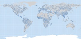
The world's navigable rivers. Image credit: NewScientist
By contrast, there are places within the bright regions of the NewScientist map where connectivity fails. A resident of the Ninth Ward of New Orleans or Cairo’s City of the Dead are only minutes away from a web of roads, rivers, and trains. Yet how often do residents use them? In these cases, remoteness is not a matter of distance, but of culture and socio-economics. How do we measure these kinds of blank spaces on the map?


Can you link to higher quality images, as much as I like struggling to see what the legend mean (I can’t even see it) I would prefer if there were some larger images to view as the pictures seem interesting…but I can’t tell.